
History
Dudley's Landscape Through Time
The town of Dudley, established in 1732, lies between the French and Quinebaug Rivers, just north of the Connecticut border. To the east, on the other side of the French River, lies Webster, to the north, Charlton, and to the west, Southbridge. The Quinebaug River runs through a steep, narrow valley in the southwest corner of Dudley.
In the northeast quadrant, the land rises to 800’ above sea level, and there are a number of small ponds and reservoirs created in the 19th century to provide water power for the town’s mills. A gneiss ridge running along the western shore of the French River is the site of several good quarries. Sutton, Charlton and Paxton loams found on the tops of drumlins provide the town with rich agricultural soil, while land bordering the French River is gravelly glacial till.
Dudley Hill was the site of a precontact Native American village, but the focus of precontact settlement in the area was Lake Chaubunagungamaug (now in Webster). The lake was an intertribal meeting place, and during the mid-17th century, became the site of a Christian Indian village under the aegis of the Reverend John Eliot. A network of native trails crossed through Dudley, including a north-south trail from Oxford to Woodstock, Connecticut, a northwest trail (probably including Dresser Hill Road), and a trail between the two rivers.
In 1681, the Nipmucs sold a large tract of land in south central Massachusetts to colonial investors, but reserved for themselves five square miles between Dudley Hill and Lake Chaubunagungamaug. Forty years later this reservation was also sold, and in 1732 Dudley became the first town incorporated in the new Worcester County.
 Dudley Hill was its geographical center, and a meetinghouse built in 1734, as well as trails improved as roads cemented the hilltop village’s importance. In 1816 Amasa Nichols established Nichols Academy in the town center. From the colonial period well into the 19th century, Dudley’s economy was mainly agrarian, dependent on dispersed farmsteads and mixed agricultural production. After that time, as the industrial working population grew, Dudley’s farmers switched to dairying. The West Dudley Cooperative Creamery was established in 1887, and by 1905, 31 dairy farms occupied a third of the town’s agricultural land. They continued, in progressively smaller numbers, to provide milk and milk products for local and regional markets until recently.
Growing industry along the French River shifted much of Dudley’s development away from the colonial village center. The section of town that lay east of the French River incorporated as the separate town of Webster in 1832, and the Norwich and Worcester Railroad was laid down along the river’s west bank in 1840. Industrial development in the mill villages of Merino, Chaseville and Perryville over the next decades attracted a large immigrant population to work in the textile mills, including Irish, French Canadians and Polish.
 During the Late Industrial Period (1870-1915), Merino Village especially continued to grow, with expansion of the Stevens mill, construction of a library and residential infill. In Perryville, downstream, workers’ tenements and a proprietor’s estate were built as mill capacity was doubled. A new textile village, Quinebaug (or Dundee) was established near the Connecticut line (1871-1872).
The early and mid-20th century saw improvement of local roads, including Routes 12, 197, and 131, for automobile traffic, where development continued at this time. Residential development also spread in Chaseville, and Nichols Academy – now Nichols College – expanded in Dudley Center. Cottages were built on Pierpont Meadow Pond (Charlton Pond) and Merino Pond. The textile industry, including a new Stevens mill built in Merino Village in 1928, continued to provide most of the employment in town, suffering a decline during the Depression, but recovering by 1940 with a wartime demand for textiles.
Community-Wide Heritage Landscape Issues
Concern for heritage landscapes is not new to Dudley. The town’s Master Plan, prepared in 2000, encompassed the incredible diversity and impact of heritage landscapes on community character in one of its Goals: “To preserve, enhance, and publicize the Town’s natural resources, agricultural resources, historic buildings and sites, unique cultural features and significant views.” A historic resource reconnaissance survey completed in the late 1984 and updated with a comprehensive survey in 2001 found many sites of historic significance throughout the town.
Open Space Protection
A number of open spaces and open space corridors were identified as important to protect. Two are priority landscapes—the French River Corridor, and the Northeast Corner. A third, the Tuft’s Branch Valley, comprises the central third of the town and encompasses resources including four of Dudley’s oldest farms, valuable wildlife habitat and some of the most scenic views in southern Worcester County, as well as two other priority landscapes, Dudley Center and Old Stagecoach Road.
Historic Building Preservation
Residents expressed concern about the long-term protection of Dudley’s heritage of Historic buildings. Demolition of buildings in the past by Nichols College, which owns many of Dudley Center’s most important architectural resources, has underscored the need to improve communication between the town and the college. A mechanism needs to be developed that can serve public and private needs while protecting the town’s important architectural heritage.
Priority Heritage Landscapes
Dudley’s priority landscapes range from the expression of the industrial revolution in mills along the French River to a thousand wild acres that have never been developed. Farms tell of Dudley’s strong agrarian roots, while a hilltop village evokes Dudley’s historic civic and intellectual significance. The landscapes which were given priority status by Dudley’s community meeting represent a range of scales and types of resources. Each landscape is also representative of other, similar properties in the town and each demonstrates the multiple layers of significance that are common to most heritage landscapes.
Natural and cultural features, individual and civic histories, combine to present property owners and concerned citizens with a complex combination of present-day issues and opportunities. The descriptions and recommendations that follow are intended to be first steps and constructive examples for what needs to be an ongoing process: to identify what is valued and irreplaceable in the community, and develop strategies that will preserve and enhance Dudley’s landscape heritage.
Dudley Center
Dudley Center is located on Dudley Hill, site of the town’s Colonial Period hilltop settlement near the geographical center of town. There are approximately 40 individual historic resources in the 200-acre village, of which Nichols College makes up over 50 acres. The resources that constitute Dudley Center lie along Center Road from the historic William Carter House (1726) on the north, where the road splits into Ramshorn Road heading northwest and Dudley Oxford Road heading northeast, to the south end of the Nichols College campus (1815, oldest building 1881). The Carter House is the oldest standing building in Dudley, and was the site of the first town meeting when the town was established.
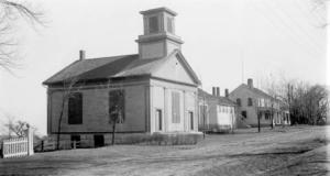 Historic buildings serve residential, academic, religious and civic uses. Many are in excellent condition while others have been updated with synthetic siding and modern windows. Examples of Colonial, Federal, Greek Revival and Victorian Eclectic architectural styles are present. Residential buildings are set back 30-50 feet while college and civic buildings around Dudley Town Common have deeper setbacks.
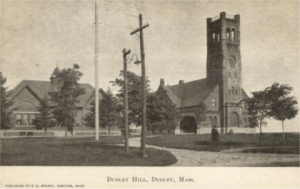
The town common fronts on the Conant Memorial Congregational Church (1891). A war memorial (1909) with stone base, bronze plaques and a bronze sculpture of an eagle sits in front of the church. The church is the central architectural resource in the area. Its brick Victorian Eclectic style cross-gabled form is dominated by a five-story tower with carillon, clock, rounded corner turrets and Romanesque detail. The Grange Hall (ca.1840) sits on the north edge of the common and the former Dudley Hill School (1890), now the Currier Center of Nichols College, borders the common to the south.
The Grange Hall is a rectangular, two and one-half story Greek Revival building ornamented with paneled corner pilasters, frieze, and a molded cornice. Across the street from the Grange Hall is the Black Tavern (1803), Dudley’s only National Register listed property. It is a classic side-gabled, Federal style commercial building two and one-half stories high. The building appears to have been built in two sections judging from the different heights of the roof. It occupies a prominent site in Dudley Center, and is one of the best preserved Federal style buildings in the area