
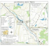
Quinebaug River Valley Rail Trail and Bikeway
The Commonwealth of Massachusetts purchased the Southbridge spur from the Providence & Worcester Railroad in 2004 to establish a community based Rail Trail system through Southbridge, Dudley, and Webster, Massachusetts. The Commonwealth had left an option open for the State of Connecticut to purchase the 3.3 miles through Thompson, Connecticut and thus creating a 13 ½ mile intermodal transportation corridor on the old Southbridge & Blackstone Railroad line which had providing connecting rail service to Boston from 1857 to 1921 and Freight services from 1857 to 1997. This railroad had physically linked those communities in the past. To date it is still only a dream for a Southbridge to Webster trail, which would include all those communities. The issue is one state cannot own property in another State.
Length: Quinebaug Valley Rail Trail; Dudley-Southbridge section; 4.1 miles. Quinebaug Valley Rail Trail; Sandersdale section; 0.2 miles
Difficulty: Quinebaug Valley Rail Trail; Dudley-Southbridge section; Easy-Moderate. Flat rail trail with multiple surfaces. Hard packed dirt, cinder, stone-dust, gravel and grass.
The northern section contains a short section of trap rock. Mt bike recommended.
Dudley Rail Trail Maps and Aids
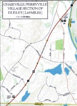
- Quinebaug River Bikeway (Rail Trail) - New Boston Road Perryville Section
- Perryville Section Quinebaug River Trail - West Dudley
- West Dudley Detailed Map
Directions:
From Route 131 in Southbridge, continue southeast on Route 131 passing the Route 169 south turnoff (Here you’ll find the paved section of trail). Continue southeast on Route 131 into Dudley. Just after you cross over the Quinebaug River, take a left on Mill Rd. The Mill Road parking lot will be along your right.
The Quinebaug Valley Rail Trail is a planned 11 mile trail that will span Southbridge-Dudley-Thomson, CT and Webster. Currently, two sections of the trail are complete. In the Sandersdale section of Southbridge a short paved trail was added when they realigned Route 169. It connects to the rail trail, but as of July 2015, the rail trail is still undeveloped. The second section of trail runs from Dudley north to the Sandersdale section of Southbridge. The trail follows the former rail bed of the Providence & Worcester RR, which originated as the Boston, Hartford & Erie RR-Southbridge Branch in 1859 and the Southbridge & Blackstone RR in 1831. The Quinebaug Valley Rail Trail is a section of the Titanic Rail Trail that is planned to run from Palmer to Franklin. Two other completed sections of the planned Titanic Rail Trail are the Grand Trunk Trail in Sturbridge and the Brimfield Trail in Brimfield. .
Starting from the Mill Road parking lot; A map board is located in the parking lot.
Note; Heading southeast, the stone-dust trail travels 0.3 miles through a wooded, residential corridor before terminating at the Connecticut border. Look left to spot the granite 1906 border post.
Heading northwest across Mill Rd past the yellow gate, the flat, cinder trail briefly follows the old rail bed for a 1/4 mile. You’ll need to utilize the dirt road for a bit as the next section of rail bed has not been developed. Road splits off left at 0.5 miles. Continue straight along the hard packed dirt rail trail as it travels alongside a ridge with fields below. After emerging from the woods you again parallel the rail bed which still has the old RR ties. The road splits right as you continue straight back along the rail trail into the woods. You hit a section of rough trap rock at 1.6 miles before coming to the Quinebaug River after 1.9 miles where the rail trail currently ends next to an old RR bridge. To your right is a bridge (West Dudley Rd) over the river. Retrace the trail back to a dirt side path that will take you out to W Dudley Rd. Then head left across the W Dudley Rd bridge. Turn right past the sign for the trail and you’ll come to the West Dudley Road parking lot. A boat launch for the QUINEBAUG RIVER WATER TRAIL is located here along with a picnic table and map board. The rail trail continues straight alongside the Quinebaug River Reservoir. You follow the hard packed cinder & grass trail along a berm between the river and wetlands before re-entering the woods at 2.4 miles and crossing into Southbridge. This section is a bit mucky in spots. Cross a bridge at 3 miles and you’ll soon be traveling alongside the Quinebaug River. Cross a second bridge at 3.5 miles where you’ll soon run into a section of trap rock which makes biking difficult. Come to Sandersdale Rd (Route 131) where the RR tracks are still embedded in the road and the trail currently ends after 4.1 miles.
Future plans call for continuing the trail north to the short paved section by Route 169, then onward into Southbridge.
Quinebaug Valley Rail Trail; Sandersdale section; Easy. Paved trail.